Why a Map Scale Changes with Zoom
Why a map scale changes with zoom, and how to choose a scale bar or ratio that matches your map so your distance estimates stay useful.
The common mistake with a map scale is treating a printed ratio as permanent after enlarging or shrinking the map. That can distort a route estimate: the ground distance stays put, but the distance shown on the page or screen changes. To use map scale reliably, match the scale information to the map’s current display size.
A map scale links two distances
A map scale compares a distance represented on the map with the corresponding distance on the ground. A ratio such as 1:50,000 means one unit measured on the map represents 50,000 of the same units on the ground. The ratio works with centimeters, inches, or another unit because both sides use the same unit.
That ratio describes a particular map image at a particular size. If a road measures two centimeters on the original map, enlarging the image makes the road longer on the page, but does not move the real road. The ratio must change to reflect that enlargement.
A scale bar stays useful when it resizes with the map
A scale bar shows a ground distance as a line drawn on the map. If the map and bar are resized together, the bar remains a useful visual reference: its drawn length changes along with the roads and landmarks. A bar labeled with ground distance is therefore usually safer than relying on a printed ratio after copying, cropping, or resizing a map.
Check that the scale bar is part of the same image or display as the map. If a screenshot captures the map but cuts off the bar, or if a document resizes one element separately, the displayed bar may no longer correspond to the map features.
Zoom changes the represented distance
On a digital map, zooming changes how much ground fits on the screen. Zoom in and a short ground distance takes up more screen space; zoom out and it takes up less. The map’s scale changes as you zoom, even if the screen itself stays the same size.
For that reason, do not apply a ratio copied from one zoom level to another. Use the scale bar shown at the current zoom, or measure a known distance visible in that same view. A screen ruler alone does not tell you how far apart two places are on the ground.
Resizing a saved map changes its ratio
Printed ratios are useful when the map is printed at its intended size. Enlarging a PDF to fit a page, shrinking a screenshot, or changing print settings alters the represented length. A feature that was one inch long on the original may take up a different length after resizing, while its real-world length remains unchanged.
Imagine you save a map image with a scale bar, then enlarge the whole image to make a trail junction easier to see. The junction and scale bar both grow, so the bar can still indicate ground distance. If you instead enlarge only the map beneath a separate, unchanged scale bar, the bar gives the wrong comparison; use a freshly displayed scale or a known distance in the resized map.
Choose the scale that fits your map copy
Use a scale bar when it is visible and attached to the map image or current screen view. It is convenient for a resized screenshot because both the map features and bar grow or shrink together. Use a printed ratio when the map is at its intended print size and you can confirm that it has not been resized.
If neither applies, look for a known ground distance shown in the same map view. A ruler can compare that distance with another feature, but only if both are displayed at the same size and the known distance is reliable. If you cannot confirm a matching scale, treat the result as an uncertain estimate rather than a precise distance.
- Digital map: Check that the scale bar is visible after setting your zoom; if it is, use it, and if it is not, return to a view that shows one.
- Paper map: Check the print settings or map markings for the intended size; if the map was printed at that size, use its ratio, and if not, use a scale bar or known distance that matches the paper copy.
- Screenshot or document: Check whether the map and scale bar were resized together; if they were, compare against the bar, and if not, find a current scale or known distance.
- Route estimate: Check whether the route bends or switchbacks; if it does, trace those sections with string or a map tool, and if it does not, a straight measurement may be suitable.
- Comparing two maps: Check each map’s own scale information; if both match their current display sizes, compare the represented distances, and if either scale is uncertain, avoid treating the comparison as exact.
- Screen measurement: Check for a visible scale bar in the same view; if present, use it to translate screen length, and if absent, do not convert a ruler reading into ground distance.
Which map scale should you use for a distance estimate?
Is a scale bar better than a ratio?
A scale bar is often easier to use after resizing because it changes size with the map when both stay together. A ratio is also valid, but only for the map at the size for which that ratio was set.
Why does the scale bar change when I zoom?
The map is showing a different amount of ground across the same screen area. The bar adjusts to represent a useful ground distance at that zoom, so read its label and drawn length together.
Can I measure a distance with a ruler on my screen?
Only if you also have a scale that matches the current display, such as the visible scale bar. The ruler gives a screen length; the scale tells you what ground distance that length represents.
Does a larger-scale map show a larger area?
No. A larger-scale map shows more ground detail in a given map area, so it usually covers less ground. A smaller-scale map covers more ground with less detail.
Trace the route instead of measuring a shortcut
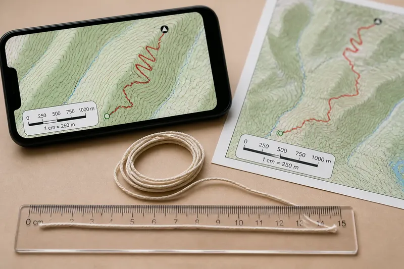
Once you have a current scale, trace a winding route in sections rather than measuring only from start to finish. A straight line between two trailheads omits bends, switchbacks, and detours visible on the map. For a rough estimate, lay a piece of string along the route, straighten it beside the scale bar, and compare its length with the bar.
Say you are viewing a trail map on a phone and zoom in until a switchback is clear. The starting inputs are the route visible at that zoom, the current scale bar, and a piece of string. Trace the route with the string, straighten it beside the bar, and use the bar’s label to convert the relative lengths into an estimate; the result accounts for the visible bends, unlike a straight line between endpoints.
When you change zoom, print size, or image size, check the scale again before measuring. Use the map scale that matches the copy in front of you, not a ratio carried over from another display.